Beidou satellite timing service details (ntp network time server timing system)
Beidou satellite timing service details (ntp network time server timing system)
Most of these services provided by the Beidou system are very easy to understand. Some of you may wonder what timing is.
Timing is simply the transmission of standard time.
In fact, the need for timekeeping has existed for a long time. We can see buildings like clock towers in many cities in the country.
A clock tower is the tool that transmits the time for a city. Everyone knows what time it is when they hear the bell and can go and do things accordingly.
We know that the current international standard time is called Universal Time Coordinated (UTC), which is based on the length of the second in atomic time combined with the moment in Universal Time. When the difference between the two accumulates year by year and reaches 0.9 seconds, the error is compensated by plus or minus 1 leap second, while maintaining an even time scale.
The timing service of BeiDou system is to disseminate the China standard time from the National Timing Center of the Chinese Academy of Sciences to the applications in various industries through satellite service to ensure the synchronization and accuracy of time.
Detailed Showcase
How to locate by satellite
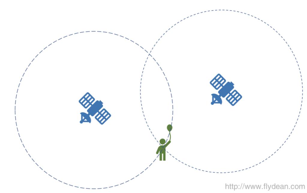
Satellites send signals to the outside at regular intervals, and our signal receivers locate the position by receiving signals from the satellites.
Suppose there are now two satellites, each maintaining a clock of its own. Suppose that each satellite sends a signal every second. At the same time the receiver maintains a clock of its own, so the receiver can calculate the distance between itself and the two satellites by determining the arrival time of the signal.
Note that above we assumed that the receiver has its own accurate clock. We will answer this question in detail later in this discussion.
Above we have drawn a two-dimensional schematic. If in a three-dimensional environment, the corresponding number of satellites has to be increased by one.
Okay, here's the question, is knowing the distance of two satellites from us enough to pinpoint our location?
The answer is no, because we don't know where the satellites are located.
01
Ephemeris and satellite positions
How can I accurately locate the position of a satellite?
As early as 1617, the great god Johannes Kepler was able to locate a satellite orbit using seven elements in an idealized model.
Of course this idealized model has some constraints: the orbit adheres to the 2D plane and is always elliptical. You can then describe this fixed orbit precisely using the following elements:
The average of the long and short axes of an ellipse (in effect: the area of the ellipse, A)
The ratio of the long and short axes of an ellipse (e).
Three parameters describing the orientation of the orbital plane: the inclination (i0), the
the longitude of the ascending node (Ω0).
Near-arch point (ω)
How far along the ellipse is the satellite at T = 0 (mean perihelion angle M0)
Moment of T = 0 (t0e)
Although Kepler's model is perfect enough, it is not enough because the Earth itself is not a perfect sphere and the gravitational field is not completely uniform. If this model was used directly, then the satellite positions could be inaccurate by kilometers.
To solve this problem, the gods who designed GPS in 1970 added six more parameters to the Keplerian model.
The figure below shows the positioning parameters used by GPS and Europe's Galileo satellite system:
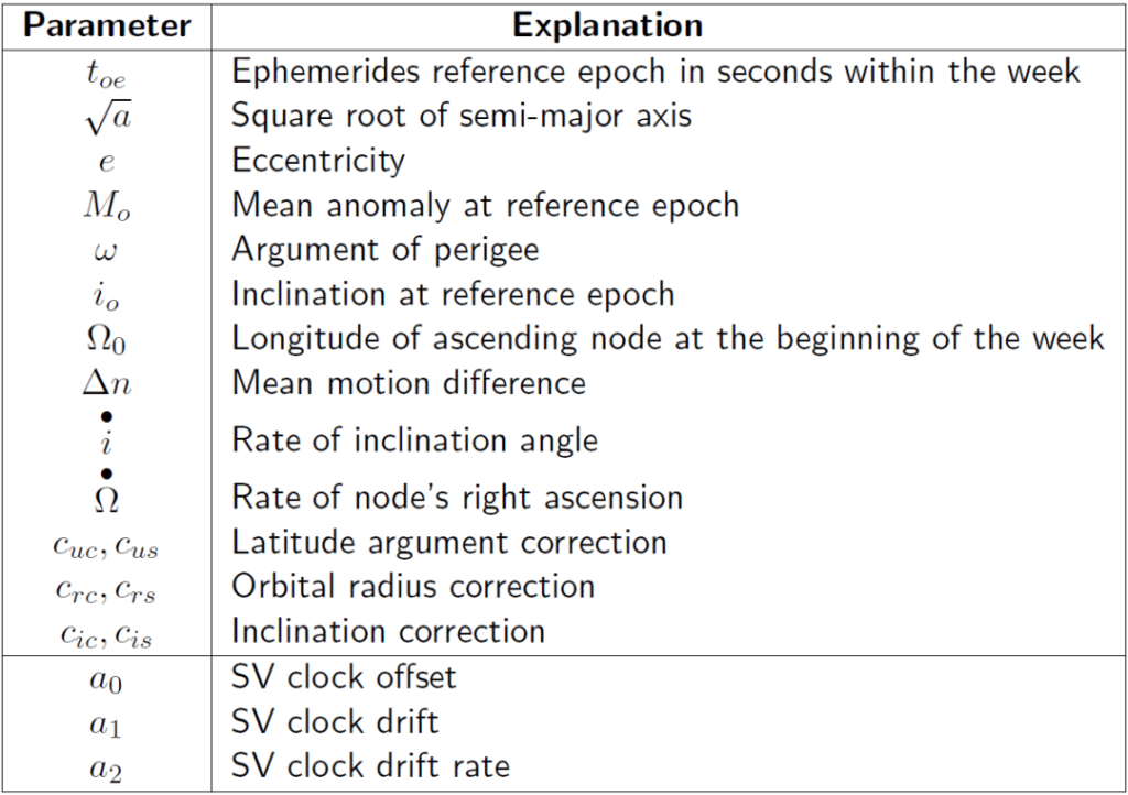
I won't go into the details of what that means, so those interested can explore on their own.
The BeiDou satellite system also follows the satellite positioning parameters of the GPS design.
Taking the Beidou satellite with the number C06@0 as an example, let's look at the signal information it provides to the outside world:
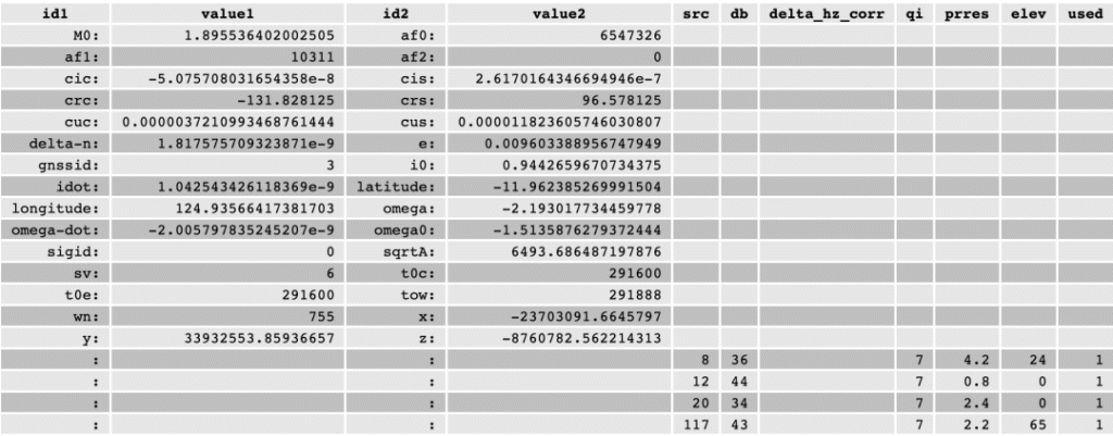
If we tally up the current satellite positions and the predictable satellite positions afterward, we generate an ephemeris.
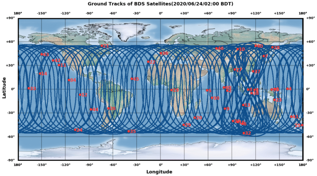
Above is the June 24, 2020 ephemeris chart for the Beidou satellite.
02
The Unknown Clock
With the position of the satellite and the distance from the satellite, we can calculate our position. But there is a prerequisite here, which is that the satellite's clock is accurate and the receiver's clock is also accurate.
There are two issues involved here, the accuracy of the satellite's clock and the accuracy of the receiver's clock.
Let's look at the issue of receiver clock accuracy first.
If the signal is traveling at the speed of light, then the error distance of one nanosecond is 30 centimeters.
Maintaining a nanosecond accurate clock is basically impossible for ordinary receiving equipment, so how can ordinary receiving equipment also be able to accurately locate?
The answer is to add another satellite.
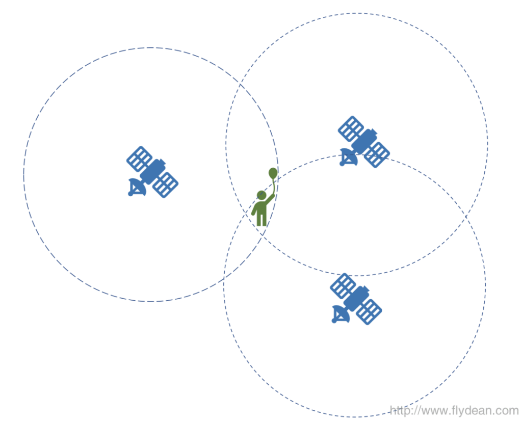
Receiving equipment at the same time to receive three signals, the same time the signal must be gathered in the actual location of the receiver that point, then the receiver can be corrected through the local clock so that multiple satellite signals are gathered in one point, thus realizing the correction of the local clock and the precise location of the positioning. Two birds with one stone.
If it's in three dimensions, you need at least four satellites.
03
Accurate clocks
We've solved the receiver's problem, how do we solve the sender's problem?
Each satellite also needs an accurate clock to send signals.
We know that the most accurate time in the world is produced in a laboratory environment, but satellites are in environments where it's impossible to achieve that kind of accuracy in a laboratory.
We can monitor the clocks in the air from the ground, compare them to the exact time in the lab environment, and send a calibration message to the satellite.
There are three main corrections:
- Clock deviation af0 nanoseconds
- Clock offset rate af1 ns/sec
- Clock offset acceleration af2 ns/sec/sec
Generally the satellite does not adjust its own clock after receiving the correction information, but sends the correction item together with the original clock to the receiver to be processed by the receiver itself.
Ionospheric error correction
Well, all the problems seem to be solved, but there's one more problem. It's the ionosphere.
Signal transmission in the ionosphere is affected, resulting in a delay.
How do you solve this signal delay problem?
This is because the delay produced by the ionosphere is proportional to the frequency of the signal. We can therefore use signals of multiple frequencies and thus derive the resulting total delay and eliminate the total delay by the difference in arrival times between the different frequency bands.
This eliminates more than 99.9% of the errors introduced by the atmosphere without performing further modeling.
As we mentioned above when we introduced the BeiDou system, the BeiDou system uses three frequency band signals, B1, B2 and B3, and the use of three frequency band signals can better eliminate the error of the ionosphere.
GPS is said to be 2 bands.